File:New Hampshire C-3 bridge posting.jpg
From OpenStreetMap Wiki
Jump to navigation
Jump to search
Size of this preview: 800 × 600 pixels. Other resolutions: 320 × 240 pixels | 640 × 480 pixels | 1,024 × 768 pixels | 1,280 × 960 pixels | 2,064 × 1,548 pixels.
Original file (2,064 × 1,548 pixels, file size: 1.55 MB, MIME type: image/jpeg)
This file and its description are from Wikimedia Commons.
Summary
DescriptionNew Hampshire C-3 bridge posting.jpg |
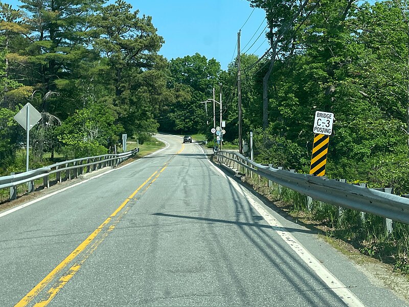
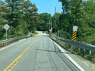
English: A bridge in New Hampshire with a C-3 bridge posting sign. |
Date | |
Source | Own work |
Author | AntiCompositeNumber |
Licensing
I, the copyright holder of this work, hereby publish it under the following license:
This file is licensed under the Creative Commons Attribution-Share Alike 4.0 International license.
- You are free:
- to share – to copy, distribute and transmit the work
- to remix – to adapt the work
- Under the following conditions:
- attribution – You must give appropriate credit, provide a link to the license, and indicate if changes were made. You may do so in any reasonable manner, but not in any way that suggests the licensor endorses you or your use.
- share alike – If you remix, transform, or build upon the material, you must distribute your contributions under the same or compatible license as the original.
Items portrayed in this file
depicts
some value
2 June 2023
0.00032894736842105263 second
1.6
4.2 millimetre
image/jpeg
File history
Click on a date/time to view the file as it appeared at that time.
Date/Time | Thumbnail | Dimensions | User | Comment | |
---|---|---|---|---|---|
current | 22:58, 5 May 2024 | 2,064 × 1,548 (1.55 MB) | wikimediacommons>AntiCompositeNumber | {{Information |Description={{en|A bridge in New Hampshire with a C-3 bridge posting sign.}} |Source={{own}} |Date=2023-06-02 |Author=User:AntiCompositeNumber |Permission= |other_versions= }} Category:Bridges in New Hampshire |
File usage
The following page uses this file:
Metadata
This file contains additional information, probably added from the digital camera or scanner used to create or digitize it.
If the file has been modified from its original state, some details may not fully reflect the modified file.
Image title | {"MAPCompassHeading":{"TrueHeading":-75.08619859854349,"MagneticHeading":-60.77168443838724,"AccuracyDegrees":10},"MAPGpsTime":"2023_06_02_19_04_55_070","MAPVersionString":"5.8.1 (5.8.1.230530)","MAPLatitude":42.984329351456594,"MAPCaptureTime":"2023_06_02_19_04_55_552","MAPGPSSpeed":14.974641314925826,"MAPDeviceModel":"iPhone 12 Mini","MAPDeviceUUID":"594514CE-4584-4BB4-B8FA-B03FF71AD26C","MAPSettingsUserKey":"100129648904841","MAPAppNameString":"mapillary_ios","MAPSettingsTokenValid":1,"MAPAltitude":17.761777803301811,"MAPLocalTimeZone":"America\/New_York (EDT) offset -14400 (Daylight)","MAPGPSAccuracyMeters":4.7020308620604991,"MAPAtanAngle":0.026664434000849724,"MAPPhotoUUID":"738A3E83-7F0E-4034-ABCE-5A54F39055CF","MAPLongitude":-70.972194876613841,"MAPSettingsUploadHash":"a8dbf1491950d22cf21ade710d7556cd8201554a4babd7c3414f5d2712313952","MAPDeviceMake":"Apple","MAPSequenceUUID":"BBDD790B-DFE5-428F-BE59-81EAA69E078E","MAPAccelerometerVector":{"x":0.98752665519714355,"y":0.026338081806898117,"z":0.15523254871368408}} |
---|---|
Camera manufacturer | Apple |
Camera model | iPhone 12 mini |
Exposure time | 1/3,040 sec (0.00032894736842105) |
F Number | f/1.6 |
ISO speed rating | 50 |
Lens focal length | 4.2 mm |
Latitude | 42° 59′ 3.59″ N |
Longitude | 70° 58′ 19.9″ W |
Altitude | 17 meters above sea level |
Orientation | Normal |
Horizontal resolution | 300 dpi |
Vertical resolution | 300 dpi |
Software used | GIMP 2.10.36 |
File change date and time | 18:33, 5 May 2024 |
Exposure Program | Normal program |
Exif version | 2.32 |
Meaning of each component |
|
APEX shutter speed | 11.569624793744 |
APEX aperture | 1.3561438092556 |
APEX brightness | 9.2800391549066 |
APEX exposure bias | 0.00390625 |
Metering mode | Pattern |
Flash | Flash did not fire, compulsory flash suppression |
User comments | {"MAPCompassHeading":{"TrueHeading":-75.08619859854349,"MagneticHeading":-60.77168443838724,"AccuracyDegrees":10},"MAPGpsTime":"2023_06_02_19_04_55_070","MAPVersionString":"5.8.1 (5.8.1.230530)","MAPLatitude":42.984329351456594,"MAPCaptureTime":"2023_06_02_19_04_55_552","MAPGPSSpeed":14.974641314925826,"MAPDeviceModel":"iPhone 12 Mini","MAPDeviceUUID":"594514CE-4584-4BB4-B8FA-B03FF71AD26C","MAPSettingsUserKey":"100129648904841","MAPAppNameString":"mapillary_ios","MAPSettingsTokenValid":1,"MAPAltitude":17.761777803301811,"MAPLocalTimeZone":"America\/New_York (EDT) offset -14400 (Daylight)","MAPGPSAccuracyMeters":4.7020308620604991,"MAPAtanAngle":0.026664434000849724,"MAPPhotoUUID":"738A3E83-7F0E-4034-ABCE-5A54F39055CF","MAPLongitude":-70.972194876613841,"MAPSettingsUploadHash":"a8dbf1491950d22cf21ade710d7556cd8201554a4babd7c3414f5d2712313952","MAPDeviceMake":"Apple","MAPSequenceUUID":"BBDD790B-DFE5-428F-BE59-81EAA69E078E","MAPAccelerometerVector":{"x":0.98752665519714355,"y":0.026338081806898117,"z":0.15523254871368408}} |
DateTimeOriginal subseconds | 539 |
DateTimeDigitized subseconds | 539 |
Supported Flashpix version | 1 |
Color space | sRGB |
Sensing method | One-chip color area sensor |
Scene type | A directly photographed image |
Exposure mode | Auto exposure |
White balance | Auto white balance |
Focal length in 35 mm film | 26 mm |
Scene capture type | Standard |
Measurement precision | Good (4) |
Speed of GPS receiver | 14 |
Direction of image | 0 |
Image width | 4,032 px |
Image height | 3,024 px |
Subject area |
|
Unique ID of original document | xmp.did:79840f09-bbea-4262-9296-3c74168561dc |
JPEG file comment | {"MAPCompassHeading":{"TrueHeading":-75.08619859854349,"MagneticHeading":-60.77168443838724,"AccuracyDegrees":10},"MAPGpsTime":"2023_06_02_19_04_55_070","MAPVersionString":"5.8.1 (5.8.1.230530)","MAPLatitude":42.984329351456594,"MAPCaptureTime":"2023_06_02_19_04_55_552","MAPGPSSpeed":14.974641314925826,"MAPDeviceModel":"iPhone 12 Mini","MAPDeviceUUID":"594514CE-4584-4BB4-B8FA-B03FF71AD26C","MAPSettingsUserKey":"100129648904841","MAPAppNameString":"mapillary_ios","MAPSettingsTokenValid":1,"MAPAltitude":17.761777803301811,"MAPLocalTimeZone":"America\/New_York (EDT) offset -14400 (Daylight)","MAPGPSAccuracyMeters":4.7020308620604991,"MAPAtanAngle":0.026664434000849724,"MAPPhotoUUID":"738A3E83-7F0E-4034-ABCE-5A54F39055CF","MAPLongitude":-70.972194876613841,"MAPSettingsUploadHash":"a8dbf1491950d22cf21ade710d7556cd8201554a4babd7c3414f5d2712313952","MAPDeviceMake":"Apple","MAPSequenceUUID":"BBDD790B-DFE5-428F-BE59-81EAA69E078E","MAPAccelerometerVector":{"x":0.98752665519714355,"y":0.026338081806898117,"z":0.15523254871368408}} |